The following is from a work-in-progress about the history of Fullerton. You can support my ongoing research and writing on Patreon.
Professor Richard (Rick) Lozinsky has taught geology at Fullerton College for the past 30 years. He recently published the third edition of his book Our Backyard Geology, which is about the geology of Orange County (including Fullerton).
I sat down with Lozinsky to learn more about the geologic history of this area and why it matters.
JL: I recently read your book Our Backyard Geology (which is about geology in Orange County), and I found it fascinating. I think it’s important for people to understand the geology of the area where they live. Could you briefly explain the geology of Fullerton?
RL: Here in Fullerton we live on an interesting spot at the edge of the Coyote Hills. There are some active faults in our area, like the Whittier Fault. Because of the faulting, we’re susceptible to earthquake hazards—liquefaction, landslides, fires. In fact, today is the day of the Great Shake-Out [a statewide campus earthquake preparedness drill].
JL: What can you tell me about the geologic history of Fullerton?
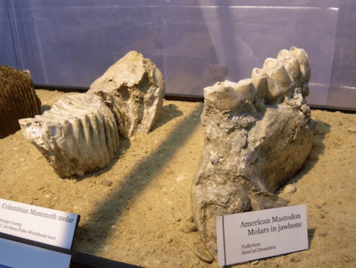
RL: Our geology is fairly young. Up until recently [geologically speaking], Orange County was part of the ocean. If you go to places like Ralph Clark Regional Park, you can actually see some of the fossil evidence of when we were part of the ocean, and then afterwards when we were dry land and had giant mammoths, mastodons, and sabre-tooth cats roaming around.
JL: How old are the rocks here?
RL: The oldest rocks we have in the Fullerton area are up in the Coyote Hills, and they only go back a few million years. If you go into the Santa Ana Mountains, like Silverado Canyon, you find some rocks that are 180 million years old. But, from a geologic standpoint, that’s still not that old.
JL: Why are the rocks so “young” here?
RL: Basically, because we were mainly ocean, and not a lot of deposition was occurring at that time. But you can go to other areas where there was mountainbuilding. There were actually times when we had exploding volcanoes in the area.
JL: When was that?
RL: About 100-150 million years ago. We had a different kind of plate boundary then, more like Oregon and Washington, and had volcanoes like Mount St. Helens around here.
JL: I find it interesting that here in California, we’re on the Pacific tectonic plate, and basically the rest of the country is on the North American tectonic plate.
RL: I tell my classes that, being west of the San Andreas fault (which is the boundary between the Pacific and North American plates), we’re on an Alaska cruise. We’re slowly, by about an inch a year, heading up toward Alaska.
JL: And that’s also why we’re more susceptible to earthquakes?
RL: Right, if you’re on a plate boundary, you’re going to have more big earthquakes.
JL: What are some of the kinds of rocks and formations that are unique to this area?
RL: A lot of sedimentary rocks: sandstone, shale, conglomerate. There’s a big bend in the San Andreas Fault that formed the San Gabriel and San Bernadino Mountains. That compression creates the rippling of the hills around us, and the LA Basin. We live in a hole that’s about 4-5 miles deep, which is filled full of sediments.
JL: I know that, historically, this was a very oil-rich area. Aside from oranges, oil was the main product of Fullerton and Brea. How does this relate to our local geology?
RL: Brea Canyon is an interesting place, because that’s where the Whittier Fault goes through. The reason the oil wells are there is because the fault is acting as a trapping mechanism. It also has to do with the fact that we used to be part of the ocean. Petroleum is formed when millions of marine organisms settle on the ocean floor, get buried at just the right depth and temperature, and it changes to petroleum.
JL: Aside from just increasing one’s knowledge, why do you think it’s important for people to understand their local geology?
RL: Well, because some people fear where they live. They fear an earthquake, they fear a flood. We have been flooded here before in Fullerton. Back in 1938, we had a major flood, where you couldn’t get to Fullerton College by street because Chapman Ave. was under a couple feet of water—students were coming by canoe. So, I think it’s better to understand your local geologic setting to get an idea of how safe it is, and things you can do to make it safer.
JL: How safe are we?
RL: From an earthquake standpoint, I think overall we’re probably fairly safe if we take precautions. It’s important to stabilize objects where you live because it’s not usually earthquakes that hurt you—it’s things that fall on you. So, if we can stabilize things that would fall on us, we can almost look forward to the next earthquake.
JL: What are some local geology groups or societies?
RL: We have the South Coast Geological Society, which is kind of the Orange County geology group. There’s a National Association of Geoscience Teachers, the far western section, which includes California. There are periodic meetings where we go and hear presentations on research that people are doing locally or internationally.
JL: Are there any current discoveries being made that you find particularly interesting?
RL: They’re trying to develop an Early Warning System for earthquakes here in California, particularly in LA. That’s pretty exciting.
JL: What do you love about geology?
RL: Geology is my life. It’s not just a job. I travel to see geology, not only locally but worldwide. I enjoy taking students out and opening their eyes to geology, particularly outside the classroom because that’s when things really can open up. I’ve been teaching here for close to 30 years, and still enjoy it quite a bit. And my roots are here in Southern California, so kind of fun to see the changes that have happened.


Leave a comment